By NAN Staff Writer
News Americas, MIAMI, FL, Mon. Oct. 13, 2014: Just as hurricane Fay weakened to a storm Sunday, the emergence of another tropical storm last evening brought with it the threat of a another hurricane to the Caribbean.
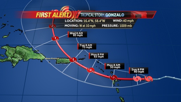
Tropical Storm Gonzalo was heading for the Leeward Islands last night and is forecast to become a hurricane by early Tuesday morning, meteorologists at the National Hurricane Center forecast.
A hurricane watch was already in effect for Puerto Rico, Vieques and Culebra, and the U.S. Virgin Islands and British Virgin Islands last night while a tropical storm warning is in effect for Guadeloupe, Desirade, Les Saintes, and Marie Galante, St. Martin, St. Barthelemy, St. Martin, Saba And St. Eustatius, Barbuda, Antigua, Anguilla, St. Kitts and Nevis and Montserrat.
A hurricane watch means that hurricane conditions are possible within the watch area and is typically issued 48 hours before the anticipated first occurrence of tropical storm force winds as conditions make outside preparations difficult or dangerous.
A tropical storm warning means that tropical storm conditions are expected somewhere within the warning area, in this case within the next 24 to 36 hours.
Gonzalo is expected to move through the Central Leeward Islands by early this morning, October 13th and approach Puerto Rico and the Virgin Islands tonight and Tuesday morning.
Maximum sustained winds are near 45 mph with higher gusts expected as the storm strengthens during the next 48 hours.
Gonzalo is expected to produce total rainfall accumulations of 4 to 8 inches across the Leeward Islands, British and U.S. Virgin Islands and eastern Puerto Rico with isolated maximum totals of 12 inches possible.
Surf swells generated by Gonzalo will affect the Leeward Islands by this morning from Dominica northward and reach the U.S. and British Virgin Islands by this afternoon. These swells are likely to cause life-threatening surf and rip current conditions.
Late last night, the center of Tropical Storm Gonzalo was located near latitude 16.4 north and moving toward the west near 10 mph. This general motion is expected to continue through today, October 13th and will followed by a turn toward the west-northwest tonight on the forecast track, the NHS said.


