By NAN Staff Writer
News Americas, MIAMI, FL, Sat. Oct. 1, 2016: Hurricane Matthew overnight lost some of its strength but still remains a major storm. The hurricane is now a category 4 hurricane, down from 5 on the Saffir-Simpson scale and is expected to remain a powerful hurricane through Monday, the National Hurricane Center in Miami said this morning.
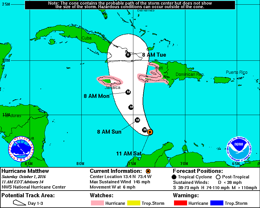
At 11 a.m. today, Matthew was now about 365 miles south, south west of Port-Au-Prince, Haiti’s capital and about 390 Miles southeast of Kingston, Jamaica with winds now at 205 miles per hour.
A turn toward the west- northwest is forecast for later today, followed by a turn toward the north-northwest on Sunday and toward the north on Monday. On the forecast track, the center of Matthew will move across the central Caribbean Sea today and Sunday, and approach Jamaica and southwestern Haiti Sunday night and Monday.
A Hurricane Watch is in effect for Jamaica while one was this morning issued for the coast of Haiti from the, southern border with the Dominican Republic to Le Mole St. Nicholas. A Hurricane Watch could be needed for portions of eastern Cuba later today.
A Hurricane Watch means that hurricane conditions are possible within the watch area. A watch is typically issued 48 hours before the anticipated first occurrence of tropical-storm-force winds, conditions that make outside preparations difficult or dangerous.
Rainfall totals of 10 to 15 inches with isolated maximum amounts of 25 inches are expected across Jamaica and southern and southwestern Haiti. This rainfall could produce life-threatening flash floods and mud slides.
The government of Colombia has discontinued the Tropical Storm Warning for that country.


