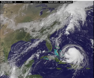
News Americas, MIAMI, FL, Fri. Oct. 2, 2015: An extremely dangerous and slow moving Hurricane Joaquin continued to hover over the Central Bahamas this morning, battering several islands there, the National Hurricane Center reported.
At 8 a.m. this morning Joaquin, a dangerous category 4 hurricane on the Saffir-

Simpson Hurricane Wind Scale, was located about 30 miles North North East of Clarence, Long Island, Bahamas and about 45 miles South South West of San Salvador, Bahamas.
Prime Minister Perry Christie said he was amending laws to allow officials to declare a national emergency and mandate evacuations because some people were refusing to move into shelters.
“We do not know the impact of 140 miles an hour on those areas,” he said, referring to the hurricane’s winds. “We know it’s a horrific kind of experience.”
Christie and other top-ranking officials also deflected accusations that the government was not prepared and that residents were not properly advised.
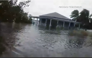
The most severe flooding reported so far was on Acklins island, where power went off overnight and phones were inoperative. Russell said some of the roughly 565 people who live there were trapped in their homes.
Maximum sustained winds were at 130 mph with the storm slowly moving AT 3 MPH. A faster northward motion is expected to begin later today, followed by a turn toward the northeast and an increase in forward speed tonight and Saturday.
On the forecast track, the core of the strongest winds of Joaquin will continue moving over portions of the central and northwestern Bahamas later today. But the good news is that Joaquin will begin to move away from the Bahamas tonight and Saturday.
A hurricane warning remains in effect for Central Bahamas, Northwestern Bahamas including the Abacos, Berry Islands, Eleuthera, Grand Bahama Island, and New Providence, The Acklins, Crooked Island, and Mayaguana in the southeastern Bahamas.
A hurricane watch is in effect for Bimini and Andros Island while a Tropical Storm Warning is in effect for the remainder of the southeastern Bahamas including the Turks and Caicos Islands and the Cuban provinces of Camaguey, Los Tunas, Holguin, and Guantanamo.
Joaquin is expected to produce total rain accumulations of 12 to 18 inches over the central Bahamas with isolated maximum amounts of 25 inches. Rainfall amounts of 5 to 10 inches are expected over the southeastern Bahamas, with 2 to 4 inches over the northwestern Bahamas, eastern Cuba, Haiti, the Dominican Republic, and the Turks and Caicos Islands. This rainfall could result in life-threatening flash floods.
A very dangerous and life-threatening storm surge will raise water levels by as much as 6 to 12 feet above normal tide levels in the central Bahamas in areas of onshore flow. A storm surge of 2 to 4 feet above normal tide levels is expected in the remainder of the Bahamas within the hurricane warning area. Near the coast, the surge will be accompanied by large and dangerous waves.
Bermuda is also now being urged to monitor the progress of Joaquin.


